This Forecast is brought to you by Jefferson Concrete LLC out of Jefferson, WI. 920-699-2262 or 920-988-1853. strobel@ag-track.com
My online merchandise store is now open for shopping! We have pick up spots for Lake Mills and Watertown and you can also get your orders shipped! All orders over $100 will be shipped FREE! You can click the button to get to the store! New stuff will be occasionally and/or swapped out. Seasonal designs will be happening. Thanks for shopping local as well. By shopping at my store, you are supporting EZ-Promotion out of Lake Mills, WI. They are doing all the production of my product and they also created the design. You are also supporting me and I thank you oh so much! Very much appreciated!
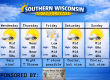
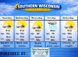
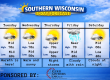
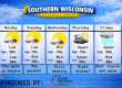
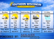
5 DAY OUTLOOK
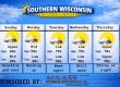
THE FORECAST
CURRENT CONDITIONS IN WATERLOO, WI:
TIME: 800PM
TEMP: 73 degrees
DEWPOINT: 65 degrees
WINDS: NW 6-11mph
CURRENT CONDITIONS: Sun and clouds
TONIGHT:
TEMPS: Near 60
WINDS: Calm
FORECAST: Clear, but some fog is possible towards morning
TOMORROW:
TEMPS: Low to mid 80s
WINDS: South 4-9mph
FORECAST: Sunny with morning fog possible
SAM’S TEXT FORECAST WITH SASS:
Good evening Southern Wisconsin! Well we had a pretty decent day to clean up the mess for those who had damage from yesterday’s tornado outbreak. There was 5 different tornadoes on the ground at some point. Tonight we will be clear with temps near 60 degrees. Some very late night fog is possible. The dewpoints and the temps will be real close and with calm winds and saturated grounds, that’s a good sign that some fog is coming.
Tomorrow we will see sunny skies and temps back into the low to mid 80s. We have clicked our AC back on and shut the windows. We needed some fresh air in the house today. It was quite cool before the sun popped out! Some morning fog is possible, but that should burn off quickly. South winds increasing to 4-9mph later in the day. Clouds to roll in Monday night and those will bring in a likely chance for rain and storms. Some moderate to heavy rainfall is possible. Lows near 70 and south winds 7-12mph. Hopefully the power can get restored by then for the people that are still out.
Sunny and HOT on Tuesday with highs in the upper 80s to near 90. This may trigger some strong to severe storms from Madison to MKE and south. West winds 11-16mph. We will have to wait and see how the day works out. Storm chances will end by midnight and we will clear out with temps in the low to mid 60s. 1-3″ of rain is possible for some from Monday night through Tuesday evening.
Sunny, cooler, and less humid on Wednesday with highs in the mid 70s and sunny skies. Clear at night with temps in the low 50s. Winds will generally be light.
Sunny and remaining cool for Thursday with temps in the mid 70s. Light winds. A few clouds at night with lows in the upper 50s.
Friday is looking wet and stormy throughout the day with temps in the mid 70s. Showers and storms likely Friday night with temps in the mid to upper 60s.
A mix of sun and clouds for Saturday with a chance for storms. Highs near 80. Clear at night with lows in mid 50s.
Sunny on Sunday with temps in the mid 70s.
Have a great night
Sam
My amazing sponsors!

Jefferson Concrete is a family owned and operated redi-mix supplier located at 870 N Watertown Ave in Jefferson. They service all of Jefferson County, and parts of Dodge, Waukesha, Walworth, Rock, and Dane counties. They supply to contractors who pour regularly and also homeowners who are looking to finish a concrete project themselves. Follow them on Facebook! Message them there or call 920-699-2262 to order a delivery.


