This weekly weather outlook is brought to you by Breathe Salt & Sauna out of Johnson Creek, WI. 920-699-9399. hello@breathesaltandsauna.com. www.breathesaltandsauna.com
My online merchandise store is now open for shopping! We have pick up spots for Lake Mills and Watertown and you can also get your orders shipped! All orders over $100 will be shipped FREE! You can click the button to get to the store! New stuff will be occasionally and/or swapped out. Seasonal designs will be happening. Thanks for shopping local as well. By shopping at my store, you are supporting EZ-Promotion out of Lake Mills, WI. They are doing all the production of my product and they also created the design. You are also supporting me and I thank you oh so much! Very much appreciated!
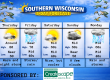
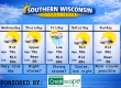
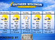
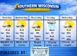
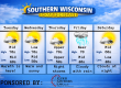
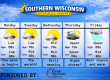
5 DAY OUTLOOK
THE FORECAST
CURRENT CONDITIONS IN WATERLOO, WI:
TIME: 730PM
TEMP: 83 degrees
DEWPOINT: 72 degrees
WINDS: South 6-11mph
CURRENT CONDITIONS: Cloudy
TONIGHT:
TEMPS: Upper 60s
WINDS: Light
FORECAST: Chance for storms mainly late evening
TOMORROW:
TEMPS: Near 80
WINDS: East 4-9mph
FORECAST: Cloudy with a chance of storms. Some maybe strong to severe
SAM’S TEXT FORECAST WITH SASS:
Good evening Southern Wisconsin! This is mainly a forecast on what’s going to happen tonight and tomorrow into Tuesday. We have a storm system coming in from the Rockies late tonight. This storm system is going to break the heat that we have been seeing. I feel like the storms we see are going to pack a punch, but we will have to wait and see. Tonight we will be cloudy with isolated to scattered storms to pop up within the next couple to few hours. There’s also a chance that these don’t fire, but we need that spark. The storms that happen tonight SHOULD behave as far as severity goes. Temps tonight will drop to near 70. Light south winds. I would say tonight is a 50/50 chance of happening. Timing for tonight would be 9pm to late night.
Tomorrow is still a big question mark in my opinion. Regardless or what happens, storms will be likely in Central and Northern WI starting tomorrow afternoon and into the evening. We will be cloudy around here and may not get enough energy to spark the storms up around here. I think if we see storms tomorrow, they may hold off until after dark. Both the 18z HRRR and hires NAM models keep the storms north. Now if we see that warm front stay north of us and we see some sunshine, then we could see some of the big time storms like the SPC is trying to say. Tomorrow is really going to be a crap shoot and I can’t give out times or locations, because it’s all dependent on that warm front for us. The SPC has us under a marginal to slight risk for a strong to severe storm. That’s a level 1 and 2. All modes of severe weather would be possible IF they form. There’s even a threat of a weak tornado or two IF that happens. The main threats would be hail and torrential rainfall. My gut is telling me we will stay cloudy and the storms will stay to our north. We shall see. Temps tomorrow with clouds will reach near 80. If we see some substantial sunshine, then the mid 80s would be possible. East winds 4-9mph. Lows tomorrow night will drop to about 60 degrees. East winds 7-12mph.
There’s a chance that some of the storms may linger into Tuesday morning. We will be cloudy through most of the day, but some sunshine is possible by late afternoon. Temps will only reach the low 70s. NE winds 11-16mph. Open those windows up!
The rest of the week is looking dry and cooler. The weekend looks dry and cooler as well.
Have a great night
Sam
My amazing sponsors!

Discover rejuvenation at Breathe Salt and Sauna! Experience the benefits of salt therapy and infrared sauna sessions in a serene environment designed to enhance your well-being. Whether you’re looking to relax, detoxify, or improve respiratory health, our state-of-the-art facilities provide the perfect escape. Visit us today and Breathe in Wellness.
920-699-9399
480 Village Walk Ln Suite B
Johnson Creek, WI


