
This Tuesday evening forecast is brought to you by Fresh View Color Consultations serving Madison to Milwaukee to Janesville and everywhere between. 262-753-3181 and freshviewcolor@gmail.com
My online merchandise store is now open for shopping! We have pick up spots for Lake Mills and Watertown and you can also get your orders shipped! All orders over $100 will be shipped FREE! You can click the button to get to the store! New stuff will be occasionally and/or swapped out. Seasonal designs will be happening. Thanks for shopping local as well. By shopping at my store, you are supporting EZ-Promotion out of Lake Mills, WI. They are doing all the production of my product and they also created the design. You are also supporting me and I thank you oh so much! Very much appreciated!
THE FORECAST
CURRENT CONDITIONS IN WATERLOO, WI:
TIME: 645PM
TEMP: 51 degrees
DEWPOINT: 38 degrees
WINDS: NE 13-18mph
CURRENT CONDITIONS: Fair
TONIGHT:
TEMPS : Low 40s
WINDS: NE 11-16mph
FORECAST: Clouds
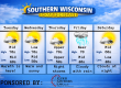
TOMORROW:
TEMPS: Low 50s
WINDS: NE 11-16mph with gusts to 25-30mph
FORECAST: Rain with possible storms(Severe chances south)
Here is your full text forecast:
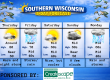
Good evening Southern Wisconsin! Happy Tuesday night! We will see an increase in the clouds for tonight with temps only dropping to the low 40s. NE winds 11-16mph. Slight chance for showers towards morning, but I think most will stay dry.
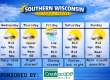
Showers likely tomorrow morning at some point. Still not real sure on the timing of the showers. I guess they will come when they want to come huh? My guess is mid morning with some stray showers before that. Some thunderstorms are possible in the afternoon. There’s a marginal risk or level 1 threat for Southern WI for some strong to severe storms. I think most of the severe chances will stay south over Northern IL. Rain will be likely through mid evening, then we could see some mixing by 8-9pm. All mixing will change over to straight snow by 9-10pm or so. Lows will dip to the mid 20s. Snow will end by late night or so. Some blowing snow is likely if we see accumulation. I am expecting a dusting to 3″ of snow. Less to the SE and more to the NW. Things can change though. Don’t be shocked to wake up to nothing or 3″ LOL. North winds will increase to 21-26mph with gusts to 35-40mph overnight. Road conditions MIGHT be a bit crappy for Thursday morning.
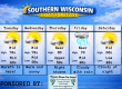
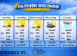
Clouds should give way to some afternoon sunshine on Thursday with temps near 40 degrees. NW winds 16-21mph with gusts to 30-35mph. Clear and cool at night with temps in the mid 20s. Light winds.
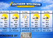
More clouds than sunshine on Friday with temps back into the mid 50s for a day. South winds 11-16mph with gusts to 25-30mph. There’s a chance for some rain at night with temps in the upper 20s. Rain will be done by the time it cools down. SW to NW winds 7-12mph.
Sunny and cooler on Saturday with temps in the low 40s. NW winds 4-9mph. More clouds at night with a slight chance for some snow with temps in the mid 20s.
Chance for a mix of snow and rain Sunday morning, then changing to rain with temps getting up to the mid 40s. Rain and snow likely Sunday night with temps near 30 degrees.
Have a great night
Sam
My amazing sponsors!

Have you ever chosen a paint color for your home and after getting it on the wall you realize it just doesn’t work? Choosing colors for your home can be a daunting task. There are so many to select from! Take away the guesswork and be sure to call Nancy at Fresh View Color Consultations. She has the experience and education needed to help you find a palette you love. Home is where your favorite colors are! Call 262-753-3181 to get started. They do both interior and exterior work. 12 years of experience! Tell her I sent you!


