
This Tuesday evening forecast is brought to you by 363 Outdoor Services serving all of Jefferson County. 608-312-6090. 363outdoorservices@gmail.com
My online merchandise store is now open for shopping! We have pick up spots for Lake Mills and Watertown and you can also get your orders shipped! All orders over $100 will be shipped FREE! You can click the button to get to the store! New stuff will be occasionally and/or swapped out. Seasonal designs will be happening. Thanks for shopping local as well. By shopping at my store, you are supporting EZ-Promotion out of Lake Mills, WI. They are doing all the production of my product and they also created the design. You are also supporting me and I thank you oh so much! Very much appreciated!
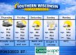
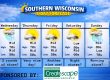
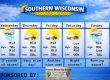
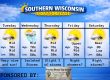
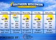
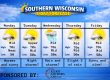
THE FORECAST
CURRENT CONDITIONS IN WATERLOO, WI:
TIME: 515PM
TEMP: 84 degrees
DEWPOINT: 72 degrees
WINDS: South 6-11mph
CURRENT CONDITIONS: Sunny
TONIGHT:
TEMPS : Low 70s
WINDS: South 4-9mph
FORECAST: Clear
TOMORROW:
TEMPS: Widespread low 90s with isolated mid 90s
WINDS: South 11-16mph
FORECAST: Sunny and hot
Here is your full text forecast:
Good evening Southern Wisconsin! It is very warm out there with tropical dewpoints! Anything over 70 degrees for a dewpoint is dumb and tropical. If I want these dewpoints, I’ll go to Mexico in the Winter LOL. We do normally get these type of hot stretches each Summer, but that doesn’t mean they are any less deadly. We still need to take the heat seriously just like we take the brutally cold. A couple clouds out there tonight and very warm with temps in the low 70s. South winds 6-11mph.
There’s a chance for some morning storms, but then turning very humid and HOT with afternoon sunshine! Everyone should make the low 90s with some isolated locations in the mid 90s. It could feel like 105 degrees at times. A heat advisory kicks in at 11am and runs until 8pm tomorrow night. Clear and hot tomorrow night with temps in the mid 70s. SW winds 6-11mph.
There’s a slight chance for a storm on Thursday, but we could also see some sunshine. That sunshine could soar temps to around 90 degrees. Showers and storms will be more likely in the later afternoon hours and evening. Some of these storms could be strong to severe. SW winds 7-12mph. Cloudy with storms possible at night with temps near 70 degrees and light winds overnight.
Still some chances for storms on Friday and cooler temps due to the clouds with highs in the mid 80s. Light winds. Cloudy and muggy at night with temps in the mid 60s. Slight chance for storms.
More clouds than sunshine on Saturday with temps again in the mid to maybe upper 80s. Light winds. A couple clouds at night and muggy with temps around the upper 60s.
Sunny and hot again on Sunday and temps near 90 degrees.
There’s really no relief from the heat and humidity in the near future! During these real hot stretches please find a friend or family member that has AC and stay with them. No one deserves to be miserable while they try and sleep. There are also some buildings open to the public during the daytime.
Have a great night
Sam
My amazing sponsors!

My amazing sponsors!

My amazing sponsors!


