
This Monday evening forecast is brought to you by Elder Advisors Law, LLC out of Janesville, WI. (844) 211-1392. https://elderadvisorslaw.com/ https://elderadvisorslaw.com/contact/
My online merchandise store is now open for shopping! We have pick up spots for Lake Mills and Watertown and you can also get your orders shipped! All orders over $100 will be shipped FREE! You can click the button to get to the store! New stuff will be occasionally and/or swapped out. Seasonal designs will be happening. Thanks for shopping local as well. By shopping at my store, you are supporting EZ-Promotion out of Lake Mills, WI. They are doing all the production of my product and they also created the design. You are also supporting me and I thank you oh so much! Very much appreciated!
THE FORECAST
CURRENT CONDITIONS IN WATERLOO, WI:
TIME: 530PM
TEMP: 69 Degrees
DEWPOINT: 45 Degrees
WINDS: SW 7-12mph
CURRENT CONDITIONS: Sunny
TONIGHT:
TEMPS: Upper 30s
WINDS: Calm to light
FORECAST: Clear
TOMORROW:
TEMPS: Near 50
WINDS: NE 11-16mph
FORECAST: Sun then clouds
Here is your full text forecast:
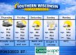
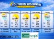
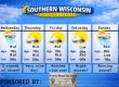
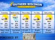
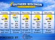
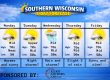
Good evening Southern Wisconsinites! We reached a high of 73 degrees according to my weather station! Clear and cool tonight with temps in the upper 30s. Winds will be calm to light.
Sunshine will lead to more clouds in the afternoon with temps only getting to near 50 degrees. There’s a stray chance for a storm while it’s daylight. NE winds 11-16mph.
Showers and storms are likely tomorrow evening, some of those storms may be strong in the SE parts of the state. Rain could change to a mix by morning with snow as temps drop to the low 30s. NE winds 11-16mph.
Snow/rain mix is likely Wednesday morning, but I am not expecting any issues around Southern Wisconsin. The further north you go, the worse the conditions. Central WI could see a little bit.
Highs in the upper 30s to near 40. NW winds 13-18mph with gusts to 25mph. A couple clouds and cold at night with temps in the low to mid 20s. NW winds 6-11mph.
Sunshine is likely to start the day on Thursday, but then clouds will move in at some point with temps in the mid 40s. West to SW winds 6-11mph.
A mix of rain and snow is likely Thursday night as lows dip into the low 30s. South winds 11-16mph with gusts to 25-30mph.
A slight chance for a morning mix on Friday, then sunny and cool with temps in the mid 40s. South winds 11-16mph and gusts to 30mph. Cloudy and cold at night with temps in the mid 20s.
Still keeping an eye on a storm system for the weekend. We could see a mix of rain and snow Saturday through Sunday. I’m not real sure what happens just yet.
Highs on Monday will be down into the mid 20s!!!! Welcome back to Winter! UGH!
Have a great night
Sam
My amazing sponsors!


