
This Monday evening forecast is brought to you by Elder Advisors Law, LLC out of Janesville, WI. (844) 211-1392. https://elderadvisorslaw.com/ https://elderadvisorslaw.com/contact/
My online merchandise store is now open for shopping! We have pick up spots for Lake Mills and Watertown and you can also get your orders shipped! All orders over $100 will be shipped FREE! You can click the button to get to the store! New stuff will be occasionally and/or swapped out. Seasonal designs will be happening. Thanks for shopping local as well. By shopping at my store, you are supporting EZ-Promotion out of Lake Mills, WI. They are doing all the production of my product and they also created the design. You are also supporting me and I thank you oh so much! Very much appreciated!
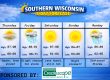
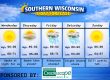
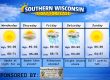
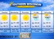
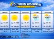
THE FORECAST
CURRENT CONDITIONS IN WATERLOO, WI:
TIME: 630PM
TEMP: 76 Degrees
DEWPOINT: 55 Degrees
WINDS: South 11-16mph
CURRENT CONDITIONS: A bit windy
TONIGHT:
TEMPS: Low 50s
WINDS: South to north 6-11mph
FORECAST: Chance for strong storms, mainly far south
TOMORROW:
TEMPS: Mid 60s
WINDS: SE to NW 8-13mph
FORECAST: Strong storms possible in the morning
Here is your full text forecast:
Good evening Southern Wisconsinites! Clouds will move into the region tonight and some areas in far Southern Wisconsin may see some storms and less likely for most of us. Large hail would be the main focus.
Temps will drop to the low 50s. South to north winds 6-11mph. AGAIN, I think most of us stay dry.
Tomorrow morning we will see some thunderstorms rapidly develop in the early to mid morning hours. Right now, I’m thinking 7am to 10am for start time. Storms would be possible through the afternoon and some may be strong.
Hail, gusty winds, and torrential rainfall all possible. Take it easy driving in it. Highs in the mid 60s. SE to NW winds 8-13mph. Cloudy tomorrow night with temps in the mid 30s and north winds 7-12mph.
Cloudy and much cooler on Wednesday with rain and snow possible in the afternoon. Temps in the low 40s. NE winds 11-16mph. Rain, thunder, and snow all possible at night with temps in the mid 30s.
East winds 13-18mph. Maybe a little slush on the roads in the morning on Thursday? I don’t think this causes issues. The further north you are the crappier roads.
A mix possible Thursday morning, then rain. A rumble of thunder is also possible. Highs will warm up to the mid 50s during the afternoon. Rain will end by midnight, then cloudy with temps in the upper 30s. South to west winds 11-16mph.
More clouds than sun on Friday with temps in the mid 50s. West to NE winds 7-12mph. Storms are likely Friday night as temps fall to near 40 degrees.
Rain likely on Saturday and maybe a mix at night. Temps in the mid 50s during the day and mid 30s at night.
More clouds than sun on Sunday with temps in the upper 40s.
Have a great night
Sam
My amazing sponsors!


