
This Thursday evening forecast is brought to you by Klecker’s Heating. 920-261-9218. info@kleckersheating.com www.kleckersheating.com
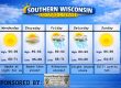
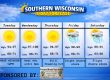
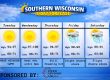
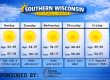
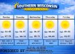
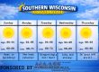
Sunday

Monday

Tuesday

THE FORECAST
CURRENT CONDITIONS IN WATERLOO, WI:
TIME: 315PM
TEMP: 61 degrees
DEWPOINT: 37 degrees
WINDS: NW 8-13mph
CURRENT CONDITIONS: Increasing clouds
TONIGHT:
TEMPS: Low 40s
WINDS: Light and variable
FORECAST: Rain
TOMORROW:
TEMPS: Near 50
WINDS: NW 6-11mph
FORECAST: Linger AM rain, then some sun
Here is your full text forecast:
Good evening Southern Wisconsin! Rain is 100% coming tonight. It will move into the area by early evening, like 6-7pm or so. Maybe 8pm for some. The latest and greatest HRRR model is actually showing some decent rainfall
between a half inch and one inch for the bottom 2 tiers of counties and less north. Northern IL could get some rain too. A rumble of thunder is possible overnight. Moderate to heavy rainfall is also possible.
Lingering rain showers will be done by 8-9am tomorrow morning and the cold front will swing through. The front will cool things off for Friday with highs near 50 degrees. NW winds 6-11mph. Could see some sunshine later. Clear and cool
tomorrow night with temps in the low 30s. Light and variable winds.
Sunny and a tickle warmer tomorrow with temps in the mid 50s. SE winds 6-11mph. Showers and maybe some storms are possible at night with temps in the mid 40s. SE winds 6-11mph. SE winds 7-12mph.
Showers and storms Sunday morning and possibly again in the afternoon. There is a risk for severe storms for far western areas. Highs in the low 70s. SW winds 16-21mph with gusts to 30mph. Chance for some showers at night with temps only
dropping to near 60 degrees. SW winds again 16-21mph with gusts to 30mph at night.
The biggest chance for strong to severe storms comes in on Monday late afternoon and into the evening. The SPC has all of Southern Wi under a level 2 or SLIGHT RISK for severe storms with all modes of severe possible. Temps will
soar to the mid to upper 70s. If we can tap into sunshine after the morning stuff, then we could see 80. It’s also going to be MOIST. Yeah get used to that word! LOL. Temps near 60 at night with storms likely. Some could be severe.
Showers and storms will be possible through Wednesday evening. From tonight through mid next week we could see a couple to few inches of rain with the stronger storms especially. The warmth will stay as well.
Have a great night
Sam
When you’re looking for a heating, air conditioning , and electrical, be sure to call Klecker’s Heating & Air Conditioning. We offer full lines of conventional equipment as well as the latest state-of-the-art high tech systems, controls and equipment. Do you find yourself in need of emergency service late at night or on a weekend or holiday? Call Klecker’s! We offer rapid response to “after hours” emergencies any time of the year. We’re conveniently located just off the highway 26 bypass at the west edge of Watertown and welcome you to stop in and pick up a filter or any special part in stock from our huge inventory of HVAC parts and supplies.
We offer expertise and products including highly efficient top quality residential Amana heating and air conditioning equipment, Lennox commercial rooftop units, TriangleTube hydronic heating boilers, state-of-the-art radiant in-floor heating and Tekmar controls, Fujitsu mini-split ductless air conditioning and heat pumps, Woodmaster outdoor wood burners, Aprilaire indoor air quality equipment, Honeywell controls and thermostats, water heaters for residential, commercial and farm use, in-floor radiant heat for farm applications where we specialize in milking parlors and runways, outdoor radiant snow melt systems and we service all brands of HVAC equipment.
My amazing sponsors!


