")
This Saturday evening forecast is sponsored by Farmers & Merchants State Bank! Waterloo is 920-478-2181. Marshall is 608-655-3451. Lake Mills is 920-630-5550. Contact them at https://www.fandmstbk.com/contact-us
My online merchandise store is now open for shopping! We have pick up spots for Lake Mills and Watertown and you can also get your orders shipped! All orders over $100 will be shipped FREE! You can click the button to get to the store! New stuff will be occasionally and/or swapped out. Seasonal designs will be happening. Thanks for shopping local as well. By shopping at my store, you are supporting EZ-Promotion out of Lake Mills, WI. They are doing all the production of my product and they also created the design. You are also supporting me and I thank you oh so much! Very much appreciated!
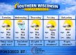
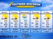
THE FORECAST
CURRENT CONDITIONS IN WATERLOO, WI:
TIME: 830PM
TEMP: 49 degrees
DEWPOINT: 35 degrees
WINDS: SE 7-12mph
CURRENT CONDITIONS: Cloudy
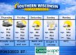
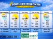
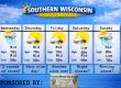
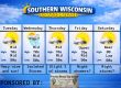
TONIGHT:
TEMPS: Mid 40s
WINDS: SE 7-12mph
FORECAST: Showers likely, storms possible
TOMORROW:
TEMPS: Low 70s
WINDS: SW 16-21mph with gusts to 35mph
FORECAST: AM and afternoon chance for storms
Here is your full text forecast:
Good evening Wisconsin! Showers are moving into the area right now. Showers and maybe storm is possible overnight. No severe weather is expected at this time. Lows in the mid 40s. SE winds 7-12mph. Half inch of rain is possible.
A chance for some morning showers and storms, then maybe some storms in the afternoon. Temps in the low 70s are expected. No severe storms are also expected at this time. More showers and storms are likely at night and some of those
might be strong, but the severe threat is low. Temps near 60 degrees at night. Very muggy for April. Very windy from the SW during the day and night.
Monday is looking dry and very warm with temps in the mid to upper 70s. SW winds 7-12mph Maybe a little sunshine as well. Monday night is when things start to look dicey. Lows in the low 60s and strong to severe storms are likely with the biggest threat being
north of Madison. There is a threat for nocturnal tornadoes. So please go to bed with a plan and don’t sleep naked! SW winds 7-12mph.
As of right now, Tuesday looks big as far as storms go and some threat for significant severe weather. Highs will get to at least 80 degrees. Some sunshine on Tuesday is likely which is bad. SW winds 7-12mph. Severe storms are looking
likely to develop in the afternoon and lingering into the evening hours. All modes of severe weather is possible with an uptick in tornado potential. The severe weather threat should be done by midnight, but overnight storms are possible.
Temps will drop to the upper 50s and south winds 7-12mph.
Cloudy on Wednesday with a chance for some storms. Some could be strong. SW winds 11-16mph. Showers possible at night with temps in the low 50s.
The rest of the week is looking warm with a break in the action on Thursday. Back to storms on Friday.
Have a great night!
Sam
Have a great night!
Sam
This Saturday evening forecast is sponsored by Farmers & Merchants State Bank! Waterloo is 920-478-2181. Marshall is 608-655-3451. Lake Mills is 920-630-5550. Contact them at https://www.fandmstbk.com/contact-us
My amazing sponsors!

My amazing sponsors!


