 (27)")
This Monday evening forecast is brought to you by Elder Advisors Law, LLC out of Janesville, WI. (844) 211-1392. https://elderadvisorslaw.com/ https://elderadvisorslaw.com/contact/
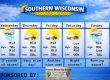
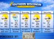
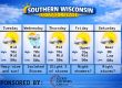
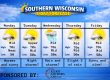
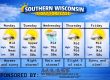
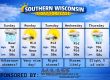
THE FORECAST
CURRENT CONDITIONS IN WATERLOO, WI:
TIME: 330PM
TEMP: 73 Degrees
DEWPOINT: 66 Degrees
WINDS: South 7-12mph
CURRENT CONDITIONS: Cloudy
TONIGHT:
TEMPS: Near 60
WINDS: South 11-16mph
FORECAST: Strong to severe storms possible
TOMORROW:
TEMPS: Near 80
WINDS: SW 7-12mph
FORECAST: Severe storms likely tomorrow afternoon into the evening
Here is your full text forecast:
Good evening Southern Wisconsinites! Showers and storms are starting to fire up north of Madison. A tornado watch has been issued north of Madison and Milwaukee for this afternoon and ending at 10pm. There’s also a
flood watch issued for those same areas. Some areas could see at least 1-2″ with isolated higher amounts. Another line of strong to severe storms will roll through the area after 10pm or so tonight. Lows near 60 degrees.
South winds 11-16mph.
Sunny for your Tuesday which is not good. Highs will jump to about 80 degrees. SW winds 7-12mph. Strong to severe storms are looking more likely over southern Wi for the afternoon and evening. The SPC
has issued southern Wisconsin under a level 3 or enhanced risk for severe storms which includes tornadoes. Showers and storms possible into the overnight hours. More showers than storms after midnight. Lows in the mid 50s and light winds.
Cloudy with a chance for strong to severe storms on Wednesday with highs near 70 degrees. SE winds 4-9mph. Showers and storms possible through the overnight hours. Lows in the mid 50s.
Showers are possible on Thursday with temps in the low 70s. Maybe a little sunshine too. West winds 6-11mph. A couple clouds overnight with temps near 50 and light or calm winds.
A little sunshine possible on Friday which isn’t good and temps once again near 80 degrees and humid. That highs temps and dewpoints may fuel some more strong to severe storms in the afternoon and evening ahead of the cold front.
Storms possible at night with temps near 50.
Cooler on Saturday with highs near 60 degrees. Showers and storms possible.
Even more cool on Sunday, but sunny with highs near 50 degrees.
Have a great night
Sam
My amazing sponsors!


