")
This Thursday evening forecast is brought to you by Klecker’s Heating. 920-261-9218. info@kleckersheating.com www.kleckersheating.com
THE FORECAST
CURRENT CONDITIONS IN WATERLOO, WI:
TIME: 315PM
TEMP: 81 degrees
DEWPOINT: 58 degrees
WINDS: South 11-16mph
CURRENT CONDITIONS: Sunny
TONIGHT:
TEMPS: Upper 50s
WINDS: South 11-16mph
FORECAST: Showers and storms possible
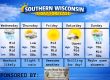
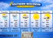
TOMORROW:
TEMPS: Upper 60s
WINDS: SW to NW 7-12mph
FORECAST: Showers and storms in the morning, possible showers in the afternoon
Here is your full text forecast:
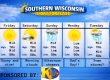
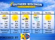
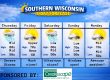
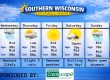
Good evening Southern Wisconsin! It’s pretty darn warm out there right now, but this is our last 80 degree day for at least the next week, so get out and get a tan after work! The rest of the afternoon will be dry and sunny, but some clouds will eventually filter in. Tonight we could see a broken line of showers and storms. The SPC has a slight risk for severe storms or level two for a very little sliver of SW Wisconsin, but the rest of us are under a marginal risk or level 1. The HRRR model has been pretty consistent with breaking up and even fizzling that line of storms around Madison. Some areas far west of Madison could see up to an inch of rain, while others well east of Madison could see 6 drops of rain. To me, the severe risk is west of Madison. The temps tonight will drop to the upper 50s with SW winds at 11-16mph.
Showers and storms are possible to likely tomorrow morning, then a slight chance of a shower in the afternoon. Temps should make the upper 60s, but may cool off in the afternoon with the passage of the cold front. SW to NW winds 7-12mph. Clear and cool tomorrow night with temps in the mid 40s and NW winds 4-9mph.
Sunny and a bit cooler on Saturday with temps in the mid 60s. North winds 6-11mph. Clouds may roll back in at night, but we will stay dry with temps in the mid 40s and light winds.
More clouds than sunshine on Sunday with temps still in the mid 60s. East winds 6-11mph. Cloudy with a slight chance for a shower Sunday night with temps in the upper 40s and east winds 11-16mph.
Monday and Monday night look to be fairly wet and stormy. Some of the storms could be strong to potentially severe. Highs in the mid to upper 60s with a strong wind out of the SE.
Just some slight chances for rain Tuesday through later next week. Highs in the mid to upper 50s potentially by Wednesday.
Have a great night
Sam
When you’re looking for a heating, air conditioning , and electrical, be sure to call Klecker’s Heating & Air Conditioning. We offer full lines of conventional equipment as well as the latest state-of-the-art high tech systems, controls and equipment. Do you find yourself in need of emergency service late at night or on a weekend or holiday? Call Klecker’s! We offer rapid response to “after hours” emergencies any time of the year. We’re conveniently located just off the highway 26 bypass at the west edge of Watertown and welcome you to stop in and pick up a filter or any special part in stock from our huge inventory of HVAC parts and supplies.
We offer expertise and products including highly efficient top quality residential Amana heating and air conditioning equipment, Lennox commercial rooftop units, TriangleTube hydronic heating boilers, state-of-the-art radiant in-floor heating and Tekmar controls, Fujitsu mini-split ductless air conditioning and heat pumps, Woodmaster outdoor wood burners, Aprilaire indoor air quality equipment, Honeywell controls and thermostats, water heaters for residential, commercial and farm use, in-floor radiant heat for farm applications where we specialize in milking parlors and runways, outdoor radiant snow melt systems and we service all brands of HVAC equipment.
My amazing sponsors!


