 (19)")
This Monday evening forecast is brought to you by Elder Advisors Law, LLC out of Janesville, WI. (844) 211-1392. https://elderadvisorslaw.com/ https://elderadvisorslaw.com/contact/
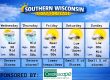
THE FORECAST
CURRENT CONDITIONS IN WATERLOO, WI:
TIME: 415PM
TEMP: 76 Degrees
DEWPOINT: 71 Degrees
WINDS: SE 11-16mph
CURRENT CONDITIONS: Rain
TONIGHT:
TEMPS: Mid 60s
WINDS: SE 6-11mph
FORECAST: Showers and storms
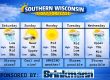
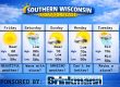
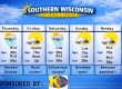
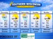
TOMORROW:
TEMPS: Mid 80s
WINDS: Light
FORECAST: Some fog and maybe a little sun
Here is your full text forecast:
Good evening Southern Wisconsinites! Showers and storms are moving through the region this afternoon and those may last into the overnight hours. Temps will drop to the mid 60s with SE winds 6-11mph. Winds may lighten up towards morning. Some patchy fog is possible overnight as well.
Some morning fog is possible tomorrow and maybe an isolated afternoon storm. Some sunshine is also possible with temps in the mid 80s and light winds. More clouds expected at night with a chance for storms towards the morning hours. Lows in the mid 60s and light winds.
Clouds in the morning, then HOT sunshine in the afternoon with temps soaring to the low 90s. South winds 8-13mph with gusts to 25mph. It will feel more like 100 degrees out there. This should trigger some afternoon and evening severe storms for some of the area. Who gets the severe storms is still up in the air. I personally think the biggest threat for Southern WI will be some major damaging winds. All modes of severe weather are possible though. Storms likely at night with temps in the mid 60s and SW winds 8-13mph and gusts to 25mph.
Still a chance for some strong to severe storms on Thursday, but the threat may stay south. It all depends what happens Wednesday. Highs in the mid 80s.
Dry on Friday and most of the weekend. Just slight chances for showers and storms Saturday and Sunday. Next week looks cooler.
Have a great night
Sam
My amazing sponsors!


