This Saturday evening forecast is sponsored by Farmers & Merchants State Bank! Waterloo is 920-478-2181. Marshall is 608-655-3451. Lake Mills is 920-630-5550. Contact them at https://www.fandmstbk.com/contact-us
THE FORECAST
CURRENT CONDITIONS IN WATERLOO, WI:
TIME: 945PM
TEMP: 70 degrees
DEWPOINT: 62 degrees
WINDS: Calm
CURRENT CONDITIONS: A couple clouds
TONIGHT:
TEMPS: Lower 60s
WINDS: Light
FORECAST: Nice Summer night
TOMORROW:
TEMPS: Near 80
WINDS: South 6-11mph
FORECAST: Late morning into afternoon strong to severe storms
Here is your full text forecast:
Good evening Wisconsinites! Clear and decent tonight with temps in the low 60s and calm to very light winds.
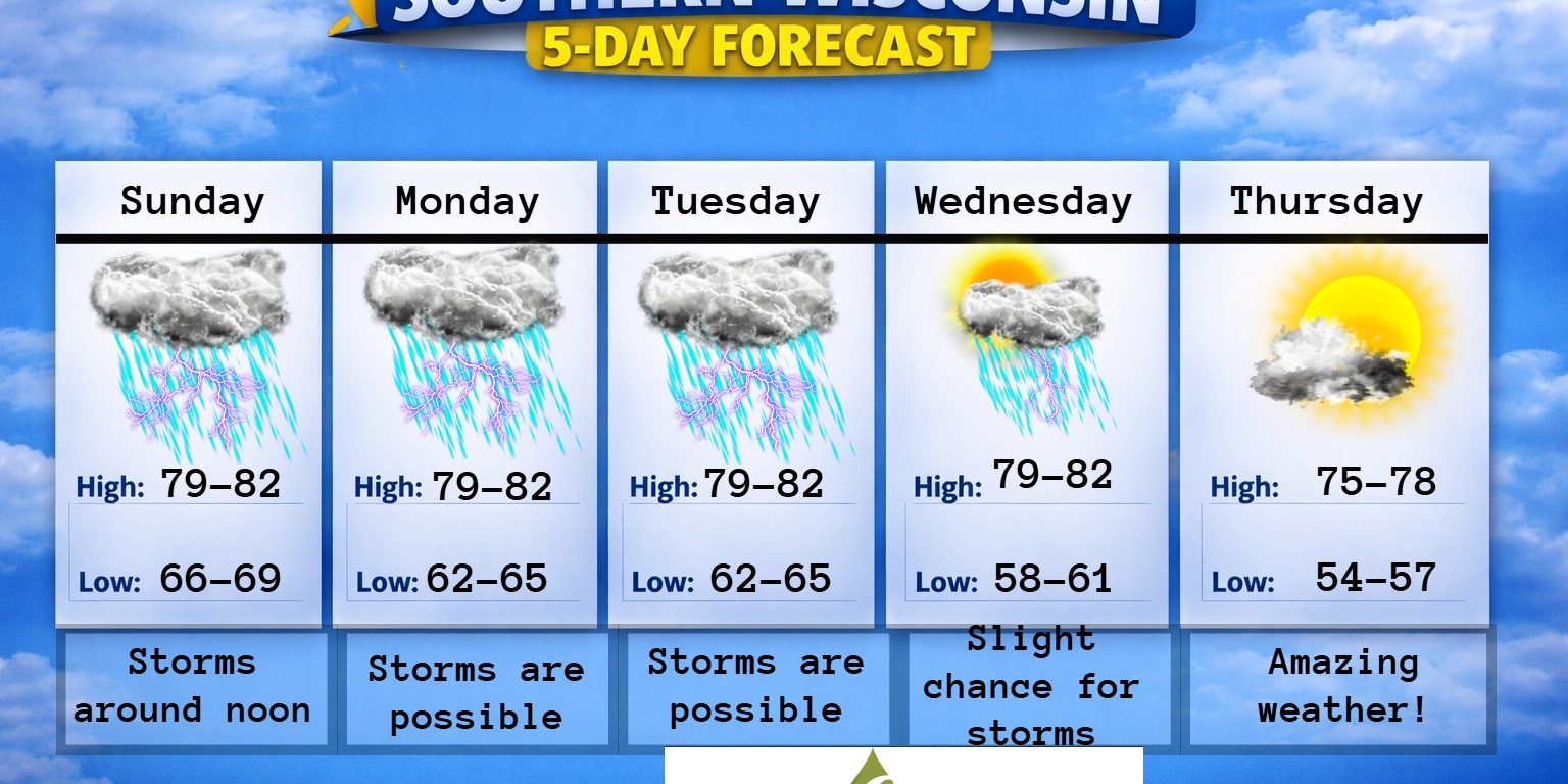
Tomorrow we will see morning clouds followed by a line of strong to severe storms by late morning and into the early afternoon hours. The main threat with these storms will be damaging winds with a lower threat for tornadoes. Just remember, Menasha was also in a 2% tornado threat. Anything can happen and it’s always best to prepare for the worst and hope for just general storms and not severe. The timing of these storms brings back flashbacks of 2 weeks ago. Some isolated showers and general storms are possible after the line rolls through in the later afternoon hours. Highs will be near 80, but it will be muggy. South winds 6-11mph. Redevelopment is likely later tomorrow evening, but most will stay over Northern IL. Some areas in far SE Wisconsin could get clipped. These storms could also be on the stronger side. Lows tomorrow night in the mid 60s with light to calm winds.
Maybe a little sunshine on Monday morning, but then another chance of storms is POSSILBE in the afternoon. The HRRR model isn’t showing much and the hires NAM shows some showers. The SPC has all of Southern Wisconsin under a marginal or level 1 risk for severe weather and a slight risk or level 2 threat over Northern IL. I’m not real confident on these storms like I am for tomorrow. Highs will reach near or just above 80 degrees with a light winds. Some patchy morning fog is also possible. Cloudy at night with a chance for some storms and temps in the mid 60s with light winds.
Cloudy on Tuesday with a chance for some storms and highs just above 80. Light winds. Some clearing possible at night, but also a slight chance for some showers and storms. Lows in the low to mid 60s and calm winds.
Some sunshine mixed with clouds on Wednesday with temps just above 80 degrees. Light winds. Slight chance for an afternoon storm. A couple clouds at night with temps near 60 degrees.
Thursday is looking dry with some sun and temps in the mid 70s! The mid 70s are likely for the rest of the week with slight chances for showers and storms.
Have a great evening!
Sam
This Saturday evening forecast is sponsored by Farmers & Merchants State Bank! Waterloo is 920-478-2181. Marshall is 608-655-3451. Lake Mills is 920-630-5550. Contact them at https://www.fandmstbk.com/contact-us
My amazing sponsors!

My amazing sponsors!