This Sunday Morning Forecast is sponsored by Jefferson Concrete LLC out of Jefferson, WI. 920-699-2262 or 920-988-1853. strobel@ag-track.com
My online merchandise store is now open for shopping! We have pick up spots for Lake Mills and Watertown and you can also get your orders shipped! All orders over $100 will be shipped FREE! You can click the button to get to the store! New stuff will be occasionally and/or swapped out. Seasonal designs will be happening. Thanks for shopping local as well. By shopping at my store, you are supporting EZ-Promotion out of Lake Mills, WI. They are doing all the production of my product and they also created the design. You are also supporting me and I thank you oh so much! Very much appreciated!
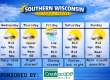
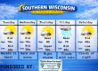
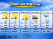
5 DAY OUTLOOK

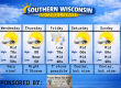
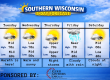
THE FORECAST
CURRENT CONDITIONS IN WATERLOO, WI:
TIME: 600am
TEMP: 61 degrees
DEWPOINT: 47 degrees
WINDS: Light NW
CURRENT CONDITIONS: Sunrise
TODAY:
TEMPS: Low 80s
WINDS: Light
FORECAST: Sunny and warm
TONIGHT:
TEMPS: Upper 50s
WINDS: Light
FORECAST: Chance for storms towards morning
SAM’S TEXT FORECAST WITH SASS:
Good morning Southern Wisconsin! We have another beautiful day on tap today if you like the very warm weather. Sunshine this morning may lead to some clouds by the afternoon. Temps will be in the low 80s, but some mid 80s will be possible towards the WI/IL border by this afternoon. Cloudy tonight and very mild with temps in the upper 50s to near 60. Some storms will become likely towards morning and some of those could be on the strong side.
Showers and storms will be likely on Monday with some strong to severe weather possible. Highs near 80 degrees and SE to SW winds 11-16mph. Showers and storms will be likely Monday night as well, but lesser chances overnight. Some of these storms could also be strong to severe. Temps will be near 60 degrees overnight. Total rainfall will vary a lot depending on where these storms set up. Anywhere from a quarter inch up to 2″ will be possible. Winds will also settle down overnight.
Tuesday is a bit of a question, but strong to severe storms will be possible during the day and likely by the evening. The warm front will be in the area for most of today and sometimes storms can generate from that. Right now, the best chance to see severe storms would be west of Madison, BUT that doesn’t mean the rest of the area won’t see severe storms. Most of our storms will be generated by a cold front that will sweep through in the evening hours. This will likely be a line of severe storms with damaging winds and small spin ups possible. Temps on Tuesday will be in the low 80s due to cloud cover. SE winds 8-13mph. Storm chances will be possible later at night with lows near 60 degrees. The entire area is under at least a SLIGHT RISK or level 2 threat with an ENHANCED RISK or level 3 from about Madison and to the west. There’s COULD be a MODERATE RISK or level 4 issued as we get closer to the event, but that may end up being for the western part of the state.
Much more quiet and less humid weather is coming for Wednesday and Thursday. Next weekend right now is looking a bit wet. More on that tonight.
Jefferson Concrete is a family owned and operated redi-mix supplier located at 870 N Watertown Ave in Jefferson. They service all of Jefferson County, and parts of Dodge, Waukesha, Walworth, Rock, and Dane counties. They supply to contractors who pour regularly and also homeowners who are looking to finish a concrete project themselves. Follow them on Facebook! Message them there or call 920-699-2262 to order a delivery.
My amazing website and Facebook Sponsors


