This Thursday forecast is brought to you by DJM Rock Walls and Bobcat Services in Belleville, WI. 608-370-4510. www.djmrockwalls.com. djmrockwalls@outlook.com
My online merchandise store is now open for shopping! We have pick up spots for Lake Mills and Watertown and you can also get your orders shipped! All orders over $100 will be shipped FREE! You can click the button to get to the store! New stuff will be occasionally and/or swapped out. Seasonal designs will be happening. Thanks for shopping local as well. By shopping at my store, you are supporting EZ-Promotion out of Lake Mills, WI. They are doing all the production of my product and they also created the design. You are also supporting me and I thank you oh so much! Very much appreciated!
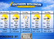
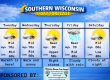
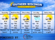
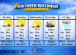
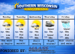
5 DAY OUTLOOK

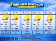
THE FORECAST
CURRENT CONDITIONS IN WATERLOO, WI:
TIME: 700PM
TEMP: 76 degrees
DEWPOINT: 51 degrees
WINDS: Light
CURRENT CONDITIONS: Sunny
TONIGHT:
TEMPS: Low to mid 50s
WINDS: Light
FORECAST: Clear
TOMORROW:
TEMPS: Mid 70s
WINDS: SE 8-13mph with gusts to 25-30mph
FORECAST: Showers and storms
Here is your full text forecast:
Good evening Wisconsinites! We made it through Thursday and one more day until the holiday weekend! Tonight we will be clear with temps in the low to mid 50s. Winds will be light and variable.
Tomorrow is a bit of a question mark. The HIRES NAM wants to shoot the morning line of storms to the north. The HRRR wants to bring that morning line of storms into Southern Wisconsin by mid to late morning. The NAM then brings a line of storms through in the early evening, while the HRRR model only brings through the one line. The NBM model shows two rounds of storms with the evening one stronger. I probably confused 64.8% of you by now. So let’s dumb it down. We are going to get wet and stormy tomorrow, but the times vary quite a bit. We are in the wait and see game. The Storm Prediction Center has some of the area under a SLIGHT RISK or level 2 threat for severe storms which includes tornadoes. The environment will be a bit ripe for them, but we will see. Temps tomorrow will be in the mid 70s. SE winds 8-13mph with gusts to 25-30mph. All storms should be gone by 10pm. We will then start to clear out as the night goes on and temps will drop to the upper 40s to near 50. South to NW winds 11-16mph with gusts to 20-25mph.
Saturday is still looking like the winner day of the week with temps in the low 70s and lots of sunshine. NW winds 4-9mph. Clouds to roll in at night with temps in the low 50s. Winds will be calm or light. We should stay dry.
Sunday is looking very wet and stormy. It’s not going to be a day where you will have a picnic. Heavy rainfall amounts are possible. Highs in the upper 60s. SE winds 11-16mph. Showers and storms likely at night with additional rainfall amounts possible. Cloudy with lows in the low to mid 50s. Rainfall amounts of 1-3″ possible through Sunday and Sunday night.
Memorial Day is looking cloudy with a chance for storms in the afternoon. You may be able to get those services in by then. NW winds 11-16mph with gusts to 25-30mph. Slight chance for storms at night with temps in the low 50s.
My amazing sponsors!

DJM Rock Walls and Bobcat Services is a family owned and operated company out of Belleville, WI. They service the Dane county and surrounding areas in SC Wisconsin. At DJM, they excel at making your vision into a reality! Whether it’s a landscaping or hardscape project to bobcat services. They strive to embrace your landscaping goals. Trust any project to DJM Walls. They have experience, expertise, and obsess about the finest details. Your satisfaction is their priority. Please consider using them for your next project and save those weekends for relaxation for yourself. Please tell them I sent you as well.


