This Forecast is brought to you by Jefferson Concrete LLC out of Jefferson, WI. 920-699-2262 or 920-988-1853. strobel@ag-track.com
My online merchandise store is now open for shopping! We have pick up spots for Lake Mills and Watertown and you can also get your orders shipped! All orders over $100 will be shipped FREE! You can click the button to get to the store! New stuff will be occasionally and/or swapped out. Seasonal designs will be happening. Thanks for shopping local as well. By shopping at my store, you are supporting EZ-Promotion out of Lake Mills, WI. They are doing all the production of my product and they also created the design. You are also supporting me and I thank you oh so much! Very much appreciated!
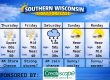
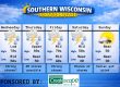
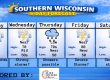
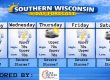
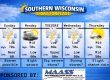
5 DAY OUTLOOK
THE FORECAST
CURRENT CONDITIONS IN WATERLOO, WI:
TIME: 730PM
TEMP: 82 degrees
DEWPOINT: 76 degrees
WINDS: Light-ish
CURRENT CONDITIONS: Storm
TONIGHT:
TEMPS: Near 70
WINDS: Light
FORECAST: Storms through about midnight, then clearing out
TOMORROW:
TEMPS: Upper 80s
WINDS: SW 8-13mph
FORECAST: Sunny and hot with severe storms in the afternoon
SAM’S TEXT FORECAST WITH SASS:
Good evening Southern Wisconsin! We have showers and storms in the area and they will continue for another few hours or so. For the most part, they are behaving. However, there are 2 severe thunderstorms out there as of 740pm. We could actually see some clearing overnight with temps near 70 degrees. Winds will be calm or light after the storms.
Sunny tomorrow and that could spill some trouble for the afternoon and evening hours. Highs will be in the upper 80s and SW winds 8-13mph. Strong to severe storms will be likely tomorrow afternoon and into the evening over Southern Wisconsin and Northern IL. These storms will produce some severe winds up to 75mph and some tornadoes will be possible as well. The SPC has Southern WI under a SLIGHT RISK or level 2 of 5 for severe storms and they also have Northern IL under a level 3 or enhanced risk. So that’s worth watching as we get into tomorrow morning. Storms should end by midnight or earlier. All modes of severe weather are possible. Lows tomorrow night will be in the upper 60s. SW to NW winds 6-11mph with the passage of the cold front.
Tuesday is still looking warm, but much nicer with temps near 80 and lots of sunshine. Light winds. A couple clouds Tuesday night with lows near 60 degrees. Winds will be calm or light.
Wednesday and Thursday look like doppelgängers with lots of sunshine and temps in the mid 70s during the day and mid 50s at night. Winds will be generally light for both days.
Friday we will remain sunny and pleasant, but a couple degrees warmer to near 80. Still not much humidity to speak of. We will be in the prolonged dry period.
The weekend also looking GREAT. Sun for both days and temps near 80 during the day and near 60 at night.
Have a great night
Sam
My amazing sponsors!

Jefferson Concrete is a family owned and operated redi-mix supplier located at 870 N Watertown Ave in Jefferson. They service all of Jefferson County, and parts of Dodge, Waukesha, Walworth, Rock, and Dane counties. They supply to contractors who pour regularly and also homeowners who are looking to finish a concrete project themselves. Follow them on Facebook! Message them there or call 920-699-2262 to order a delivery.


