
This Tuesday evening forecast is brought to you by Fresh View Color Consultations serving Madison to Milwaukee to Janesville and everywhere between. 262-753-3181 and freshviewcolor@gmail.com
My online merchandise store is now open for shopping! We have pick up spots for Lake Mills and Watertown and you can also get your orders shipped! All orders over $100 will be shipped FREE! You can click the button to get to the store! New stuff will be occasionally and/or swapped out. Seasonal designs will be happening. Thanks for shopping local as well. By shopping at my store, you are supporting EZ-Promotion out of Lake Mills, WI. They are doing all the production of my product and they also created the design. You are also supporting me and I thank you oh so much! Very much appreciated!
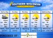
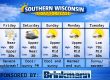
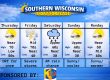
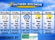
THE FORECAST
CURRENT CONDITIONS IN WATERLOO, WI:
TIME: 630PM
TEMP: 43 degrees
DEWPOINT: 42 degrees
WINDS: SE 6-11mph
CURRENT CONDITIONS: Rain
TONIGHT:
TEMPS : Upper 30s
WINDS: SE to NE 11-16mph with gusts to 25-30mph
FORECAST: Rain and maybe some thunder
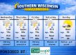
TOMORROW:
TEMPS: Near 40, then dropping to about 30 later
WINDS: North 21-26mph with gusts to 35-40mph
FORECAST: AM rain, afternoon snow Dusting to 3″
Here is your full text forecast:
Good evening Southern Wisconsin! Sorry about the delayed forecast from this morning. I for some reason have to hit post twice and must have only hit post once, but I got it out LOL! The key words tonight will be rain, maybe thunder, and some wind. The key words for tomorrow will be rain changing to snow, dropping temps, and extremely windy! Tonight we will see rain likely overnight with temps in the upper 30s. SE to NE winds 11-16mph with gusts to 25-30mph.
Tomorrow morning we could see that rain change to a mix and then change to all snow by the afternoon. There’s going to be some surprises with this. North of Madison COULD MAYBE see a few inches of snow depending when the changeover takes place and how hard it snows. The dells could see 2-6″ of snow whereas Madison could see an inch or two of slushy snow. Near the WI/IL border could see a dusting to 1″. So the amounts could vary a lot from location to location. Temps will be near 40 degrees early and dropping to near 30 degrees during the afternoon. North winds will really ramp up at 21-26mph with gusts to 30-40mph. Higher winds likely west of Madison. This could reduce the visibility quite a bit once it starts snowing. The snow COULD come down in buckets too. The ground is going to be very wet still from all the rain that has fallen. That would impact the snow accumulations. Snow ending during the evening hours, then we may clear out and get colder. This could lead to all the liquid on the ground freezing. The morning commute could be a little slickery.
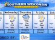
Thursday I am expecting sunshine and temps back to near 40 degrees. NW winds 8-13mph. Cloudy at night with a slight chance for some flurries or light snow. Light winds and temps in the mid to upper 20s.
Cloudy in the morning on Friday with a slight chance for some snow showers, but then we should see some sunshine with temps near 40 later on in the day. NW winds 4-9mph. Clear at night with temps in the mid 20s.
The weekend is looking dry and sunny for both days and both days will be in the low 40s for highs. The big warm up is coming next week where temps could be in the mid 60s by Tuesday.
Have a great night
Sam
My amazing sponsors!

Have you ever chosen a paint color for your home and after getting it on the wall you realize it just doesn’t work? Choosing colors for your home can be a daunting task. There are so many to select from! Take away the guesswork and be sure to call Nancy at Fresh View Color Consultations. She has the experience and education needed to help you find a palette you love. Home is where your favorite colors are! Call 262-753-3181 to get started. They do both interior and exterior work. 12 years of experience! Tell her I sent you!


