
This Tuesday evening forecast is brought to you by Fresh View Color Consultations serving Madison to Milwaukee to Janesville and everywhere between. 262-753-3181 and freshviewcolor@gmail.com
My online merchandise store is now open for shopping! We have pick up spots for Lake Mills and Watertown and you can also get your orders shipped! All orders over $100 will be shipped FREE! You can click the button to get to the store! New stuff will be occasionally and/or swapped out. Seasonal designs will be happening. Thanks for shopping local as well. By shopping at my store, you are supporting EZ-Promotion out of Lake Mills, WI. They are doing all the production of my product and they also created the design. You are also supporting me and I thank you oh so much! Very much appreciated!
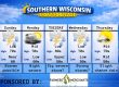
THE FORECAST
CURRENT CONDITIONS IN WATERLOO, WI:
TIME: 530PM
TEMP: 17 degrees
DEWPOINT: 4 degrees
WINDS: Light
CURRENT CONDITIONS: Cloudy
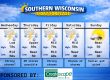
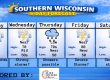
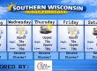
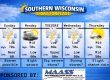
TONIGHT:
TEMPS: Mid to upper teens
WINDS: Light to calm
FORECAST: Cloudy with some flurries possible off the lake
TOMORROW:
TEMPS: Low 30s
WINDS: SE 4-9mph
FORECAST: Cloudy for most of the day, then light snow and freezing drizzle by early evening
Here is your full text forecast:
Good evening Southern Wisconsin! Tonight we will be cloudy and cool with temps in the mid teens. Light winds will become calm. Flurries are possible off the lake in SE WI.
Cloudy to begin your day tomorrow and temps should make it to near 30 degrees. There’s a chance for some flurries during the day. A better chance for light snow, freezing drizzle, and/or sleet comes in by late afternoon or early evening. I DO NOT expect huge problems on the roads. The salters that will be out will keep the mains non slick. Some of the side roads could become slimy. Snow accumulation of a dusting to half inch and ice up to 0.05″. The bulk of the precip will go well to the north and the freezing rain threat will stay south over Northern IL. SE winds 4-9mph. The precip will be likely in the evening hours, but should be done around midnight or so. Lows will drop to the mid 20s. Light winds at night.
Thursday will start out cloudy and some of the side roads may be slick for the morning commute. We will then see some afternoon sunshine and that will warm us up to near 40 degrees. West winds will increase to 16-21mph with gusts to 25-30mph. So it won’t feel like 40! Clear and cool at night with temps in the low teens. NW winds 8-13mph with gusts to 20-25mph.
More clouds than sunshine on Friday with temps in the mid to upper 20s. Light or calm winds. Cloudy Friday night with temps near 20 degrees. Calm or light winds.
Another more likely chance for snow comes in on Saturday and lingers into Saturday night. Right now, I’m thinking 1-4″ of snow around Southern WI and a few more inches well to the north. Obviously we are still a few days away and things can still change. I will keep an eye on the models and keep you updated. Next week is looking dry and colder.
Have a great night
Sam
My amazing sponsors!

Have you ever chosen a paint color for your home and after getting it on the wall you realize it just doesn’t work? Choosing colors for your home can be a daunting task. There are so many to select from! Take away the guesswork and be sure to call Nancy at Fresh View Color Consultations. She has the experience and education needed to help you find a palette you love. Home is where your favorite colors are! Call 262-753-3181 to get started. They do both interior and exterior work. 12 years of experience! Tell her I sent you!


