
This Saturday evening forecast is sponsored by Farmers & Merchants State Bank! Waterloo is 920-478-2181. Marshall is 608-655-3451. Lake Mills is 920-630-5550. Contact them at https://www.fandmstbk.com/contact-us
My online merchandise store is now open for shopping! We have pick up spots for Lake Mills and Watertown and you can also get your orders shipped! All orders over $100 will be shipped FREE! You can click the button to get to the store! New stuff will be occasionally and/or swapped out. Seasonal designs will be happening. Thanks for shopping local as well. By shopping at my store, you are supporting EZ-Promotion out of Lake Mills, WI. They are doing all the production of my product and they also created the design. You are also supporting me and I thank you oh so much! Very much appreciated!
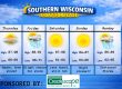
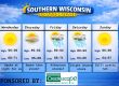
THE FORECAST
CURRENT CONDITIONS IN WATERLOO, WI:
TIME: 415PM
TEMP: 39 degrees
DEWPOINT: 37 degrees
WINDS: SE 4-9mph
CURRENT CONDITIONS: Cloudy
TONIGHT:
TEMPS: Near 40
WINDS: Light
FORECAST: Cloudy with light rain possible
TOMORROW:
TEMPS: Near 50, then dropping
WINDS: NW 11-16mph in afternoon
FORECAST: Rain likely throughout the day, then snow at night
Here is your full text forecast:
Good evening Wisconsin! The next 36 hours is going to be a bit of a wild ride. Rain and near 50 tomorrow to temps in the mid teens and snow tomorrow night. This is a strong storm system that will drop a bunch of snow in Central and Northern WI along with the UP Michigan. Some areas up there could exceed 20″. We will be mainly on the warm side of the system will wrap around snow. Tonight we will be warm with some rain possible. Widespread fog is likely overnight. Winds will be light.
Rain likely tomorrow by late morning and especially in the afternoon. Temps will reach about 50 degrees, then they will tumble by late afternoon into the early evening. Half inch of rain is possible. NW winds will increase to 11-16mph. Rain will mix with or change to snow tomorrow evening for most of us. Far Southern and far SE Wisconsin may stay rain for awhile longer than the rest of us resulting in less snow. Snow may become moderate to at times heavy during the overnight hours. West winds will increase throughout the evening and really ramp up overnight with 26-31mph sustained winds and gusts to 40-45mph. This will create near 0 visibility driving conditions overnight and into Monday morning. Temps will tumble into the mid teens and a flash freeze is possible for the west areas. Blowing and drifting snow are likely.
Snow will continue into Monday morning along with the very strong winds. This will create some issues going to work for us. Hopefully you have next week off too! The snow will end by noon, BUT the blowing and drifting snow will continue throughout the day and into the evening. This will cause crappy road conditions to continue. Highs will reach the low to mid 20s for temps. NW winds 21-26mph with gusts to 40-45mph. Clear with blowing snow at night and very cold with temps falling to the single digits. NW winds will decrease at night to 11-16mph with gusts to 25-30mph. This will lessen the chance for more blowing and drifting snow.
Tuesday and Wednesday look dry with seasonal temps in the mid 20s and just slight chances for some flurries. NYE night we could see a little accumulating light snow that could cause some slick roads. Make sure you have a designated driver or someone to pick you up. Lots of places offer free ride home.
Have a great night!
Sam
This Saturday evening forecast is sponsored by Farmers & Merchants State Bank! Waterloo is 920-478-2181. Marshall is 608-655-3451. Lake Mills is 920-630-5550. Contact them at https://www.fandmstbk.com/contact-us
My amazing sponsors!

My amazing sponsors!


