Good morning followers,
Well we made it through day 1 of me being absent from forecasting the weather and you learned about thunderstorm development and lightning facts and safety. Today I begin a couple topics on severe weather. This morning we will be talking about the outlooks that are put out by the Storm Prediction Center when severe storms are in the forecast.
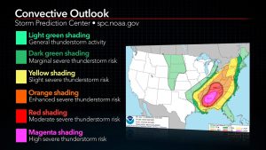
The Storm Prediction Center(SPC) puts out outlooks for day 1 through day 8. Days 1-3 they go more in depth. Days 4-8 are just a general area. When severe weather is predicted they use colors to predict how severe the weather could potentially be.
0- Light Green is just general thunderstorms
1- Dark green is a MARGINAL RISK which is a level 1 of 5
2- Yellow is a SLIGHT RISK which is level 2 of 5
3- Orange is an ENHANCED RISK which is level 3 of 5
4- RED is a MODERATE RISK which is a level 4 of 5
5- Pink is a HIGH RISK which is the highest level of 5
Most of Wisconsin’s severe weather outlooks are 1-2 levels. We do get the occasional 3 and 4. The HIGH RISK is the pink area. The entire US averages 1-2 per year and are usually in tornado alley. We probably get a high risk once every 5 years or so. That’s just my guess!
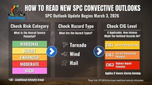
Starting March 3, 2026, the NOAA Storm Prediction Center (SPC) updated its convective outlooks to include “Conditional Intensity Groups” (CIGs), replacing the old “significant severe” hatching. These new, patterned, and numbered zones (1-3) on maps show the potential intensity (how violent) of tornadoes, wind, and hail, rather than just the probability of occurrence. The familiar 5-level risk categories (Marginal-High) remain unchanged, but the new system provides better, faster insight into whether a threat is high-end or low-end
If you can PLEASE save these photos for later use when we get severe weather. Print them off and put them on the fridge.